Learn more about the ideas and programs behind the National Resilience Council’s resilience advocacy:
Prepare. Adapt. Transform | Resiliency Leadership | Resilience Scorecard for Local Government | Integrated Risk Assessment
Prepare. Adapt. Transform.
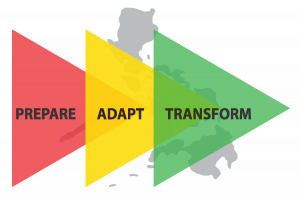
NRC defines the critical actions and measures towards resilience in terms of the three (3) Thematic Areas of Prepare, Adapt, and Transform. These areas are also considered the three phases for its Resilient LGU Program which in turn guide its partners—the local government units (LGUs)—in addressing specific questions on disaster resilience.

Prepare Thematic Area answers the question: “how can we minimize loss of lives and assets?”. Under this, LGUs conduct Climate and Disaster Risk Assessment (CDRA)-based evaluations of the risks present in their communities by identifying the hazards, exposures, and vulnerabilities (social and environment). This also involves a strengthened Management Information System and establishment of a core resilience team consisting of different pillar and sub-pillar champions, including people’s organizations and representatives from the private sector.
As it answers the question “how can we improve existing systems to reduce risks and vulnerability to hazardous events?”, the Adapt Thematic Area requires the LGU to begin institutionalizing new arrangements for disaster response, as well as for disaster preparedness by minimizing risks. Risks can be minimized by identifying and addressing the vulnerabilities of people, environment, infrastructure, and systems to hazardous events. This becomes possible by practicing co-ownership and establishing trust-based partnerships among the different sectors who will work together to improve the systems.
Lastly, new partnerships and creative solutions are expected in the Transform Thematic Area to answer the question: “how can we change existing systems to achieve resilience?”. This is where new science-based partnerships between public and private sector are formed, responsive policies are enacted both at the national and local level, communities are empowered by participating in the decision-making process with the LGU leaders and all stakeholders are encouraged to co-own the vision of resilience and work together to co-create solutions to the challenges they face.
Resiliency Leadership
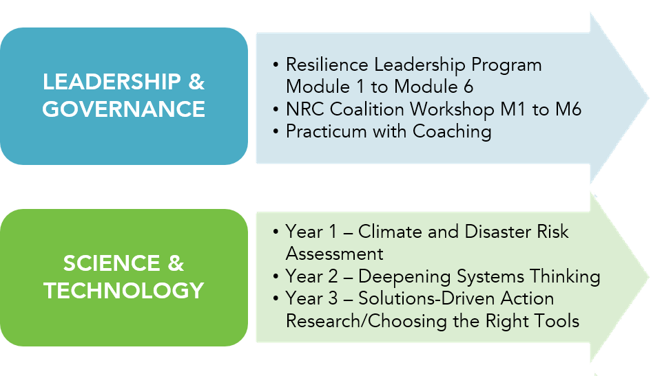
NRC’s Resiliency Leadership Program is a three-year program running along the tracks of Leadership & Governance (L&G) and Science & Technology (S&T) that guides and capacitates LGUs in developing and implementing their own resilience initiatives. This is supported by a localized Resilience Scorecard that spans the key systems of an LGU on Leadership and Governance, Human Development, Local Economy, Infrastructure and Environment. Each year will comprise of two capacity building modules and will correspond to a stage that will build on each other to achieve disaster resilience—PREPARE, ADAPT and TRANSFORM.
With a localized approach to DRR and backed with both international and national guiding documents, NRC envisions a stronger foundation for the Philippines against potential hazards and risks.
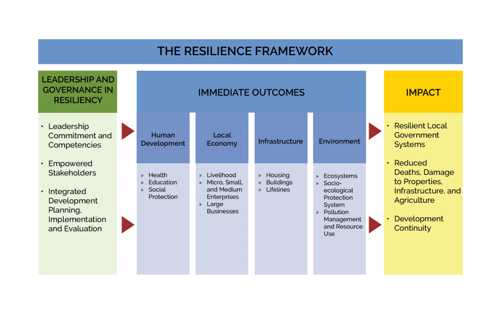
NRC’s work is guided by the Resilience Framework, a science and technology-based, evidence-informed resilience approach promoting the importance of public-private partnerships in establishing resilient local government systems.
Its key component is Leadership and Governance due to the critical role of the Local Chief Executives and the local officials who are at the forefront of their communities before, during and after disasters. With its focal areas—Leadership Commitment and Competencies, Empowered Stakeholders and Integrated Development Planning, Implementation, and Evaluation—this component will be the cross-cutting capacity building process of the NRC resilience approach.
The immediate outcomes of these capacity building processes are in the context of the four (4) pillars of the local government systems, namely: Human Development; Local Economy; Infrastructure; and Environment.
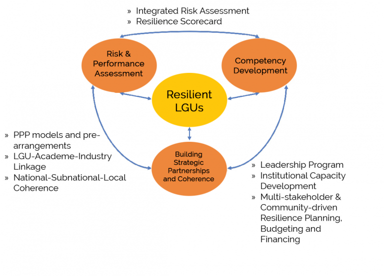
The Resilient LGU Model illustrates the key components of Resilient LGUs, the heart of NRC’s Resilience Initiative, which are:
- Risk and Performance Assessment
- Competency Development
- Building Strategic Partnerships and Coherence
Risk and Performance Assessment and Competency Development involves Integrated Risk Assessment and the Resilience Scorecard. The interplay between Competency Development and Building Strategic Partnerships and Coherence will result to the Leadership Program, Institutional Capacity Development, and Multi-stakeholder and Community-driven Resilience Planning and Budgeting and Financing. Meanwhile, Building Strategic Partnerships and Coherence and Risk Performance Assessment develop into PPP or Public and Private Partnership Models, LGU-Academe-Industry Linkage, and National-Subnational-Local Coherence.
Resilience Scorecard for Local Government
The Resilience Scorecard is a guide for NRC’s Partner Local Government Units to determine their preparedness, adaptation, and transformation towards resiliency. The NRC refers to the United Nations Office for Disaster Risk Reduction (UNISDR) definition of resilience as “the ability of a system, community, or society exposed to hazards to resist, absorb, accommodate, adapt, transform, and recover from the effects of a hazard in a timely and efficient manner, including the preservation and restoration of its essential basic structures and functions through risk management.”
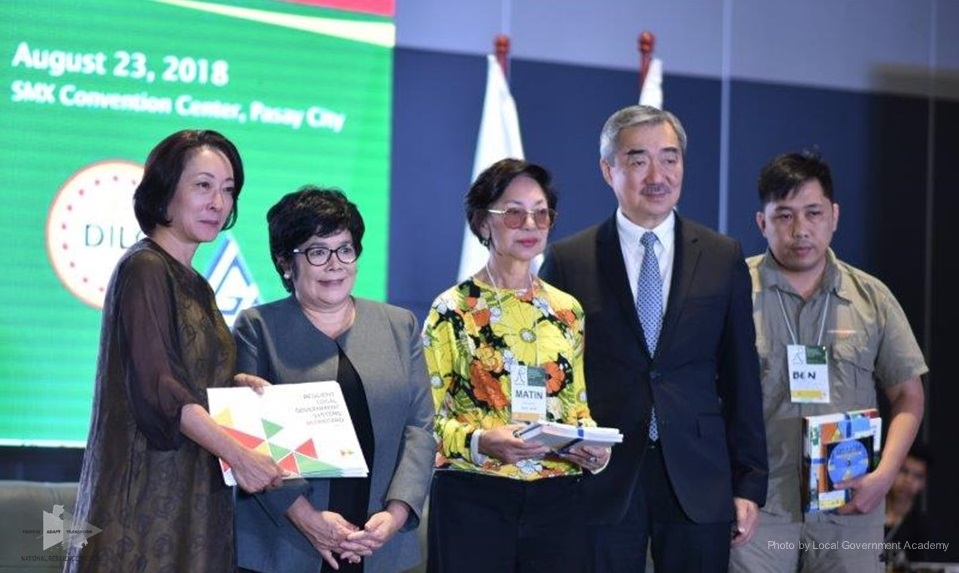
It is unique since its indicators, minimum requirements, means of verification, and references are patterned after the needs of local government systems. It is based on national instruments, Department Orders, Memoranda, Manuals, and Protocols of key government line agencies, most notable of which are the Philippine Development Plan (PDP) 2017-2022 and the Department of Interior and Local Government’s (DILG) Seal of Good Local Governance (SGLG).
Its indicators are also vetted by content experts from pertinent government agencies, the private sector, academic and scientific organizations and Civil Society or Non-Government Organizations. The primary data gathered from such consultations are also backed up by secondary data from the Sustainable Development Goals (SDGs), the resilience assessment tools of the UNISDR and its Ten Essentials for Making Cities Resilient, and the Rockefeller Foundation’s City Resilience Index.
Integrated Risk Assessment
Part of NRC’s program is a certificate course on the Climate and Disaster Risk Assessment (CDRA) which comes in three phases: Training that includes lectures, demonstrations, and hands-on exercises; Coaching and mentoring; and Integrated risk mapping. it will involve both physical and social dimension for a more holistic approach on risk assessments.
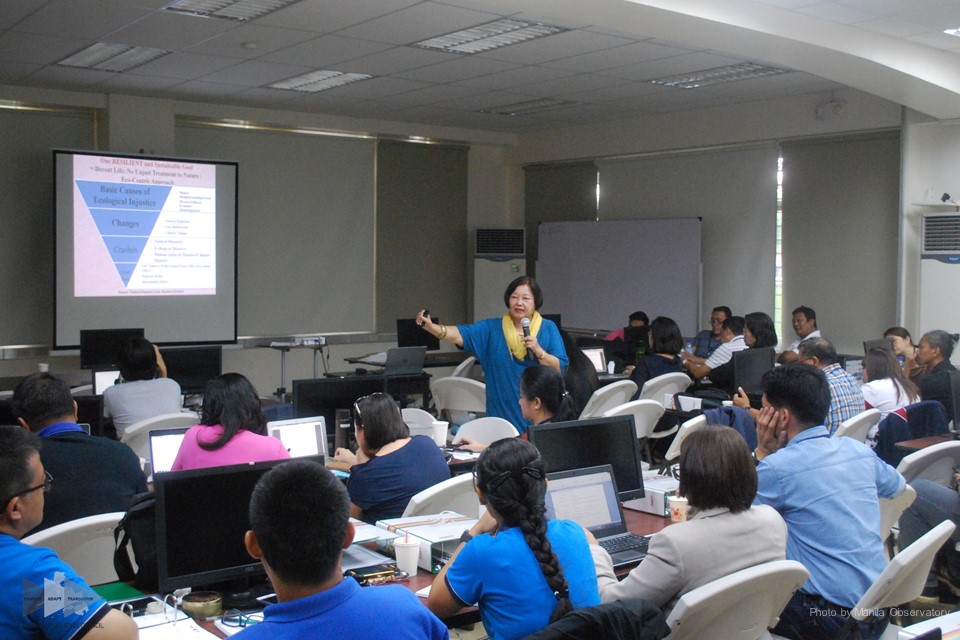
Lectures, Demonstration and Hands-On, Coaching, and Mentoring
These will be available to the trainees of the course to ensure that they will identify risk baselines and targets through scorecards and to chart resilience roadmaps for the prepare, adapt and transform thematic areas.
Risk Assessments and Geospatial Databases
As the final output, it will contain a combination of layers categorized as Hazard, Exposure, Vulnerability (HEVs) at different scales with respect to space and time. Generated and presented maps should be according to pillars and sub-pillars of the resilience framework and scorecard.
Who should take this course?
- Points of Contact and key decision support staff for Disaster Risk Reduction and Management
- Planning and Development staff in charge of climate change adaptation and risk reduction
- Environment and Natural Resources staff engaged in protection, management and restoration of ecosystems
- Social Protection and Local Economic Planning officers
Suggested Prerequisites:
Current or planned access to RS-GIS facilities/tools (i.e Data, software, hardware, personnel, protocols, systems, related programs and projects)
Prior orientation and training in the use of space-based tools, such as RS-GIS
Completed CDRA TNA and Capacity Assessments

Training Objectives:
After the 5-day training, the trainees should be able to outline a localized risk mapping project and data gathering proposal. Specifically, they should be able to:
- Enumerate risk mapping research questions;
- Identify hazard, exposure, and vulnerability (HEV) matched variables for risk mapping;
- Determine a Management Information System (MIS) and data gathering strategy for special databases and maps;
- Document risk mapping methods; and
- Conceptualize a work program with an activity-based budget
Training Schedule
Day 1
- Fundamentals and Approaches of Climate Disaster Risk Assessments (CDRA)
- Social Dimensions of Risk and Resilience
- HEV Analyses
Day 2
- Data Gathering and Risk and Resilience MIS
- Remote Sensing-Geographic Information Systems (RS-GIS)-Cartography
- Mapping Applications
Day 3
- Fundamental RS-GIS Processes Common to HEVRI Mapping
Day 4
- Application of GIS Tools for Integrated Risk Mapping (Risk Overlays and Risk Indexing)
Day 5
- Application of GIS Tools for Integrated Risk Mapping (Criteria-based and Hybrid Risk Mapping Methods)
